
Content created by Office of Global Affairs (OGA)
The U.S. – Mexico Border Area
The 1983 La Paz Agreement defined the United States - Mexico border region as the area 100 kilometers (62.5 miles) north and south of the international boundary. Stretching approximately 2,000 miles from the southern tip of Texas to California, the region includes 44 counties in four U.S. states—Arizona, California, New Mexico, and Texas, and 80 municipalities in six Mexican states—Baja California, Chihuahua, Coahuila, Nuevo Leon, Sonora, and Tamaulipas. Data and statistics about the border may appear different depending on how the geographic area is defined.
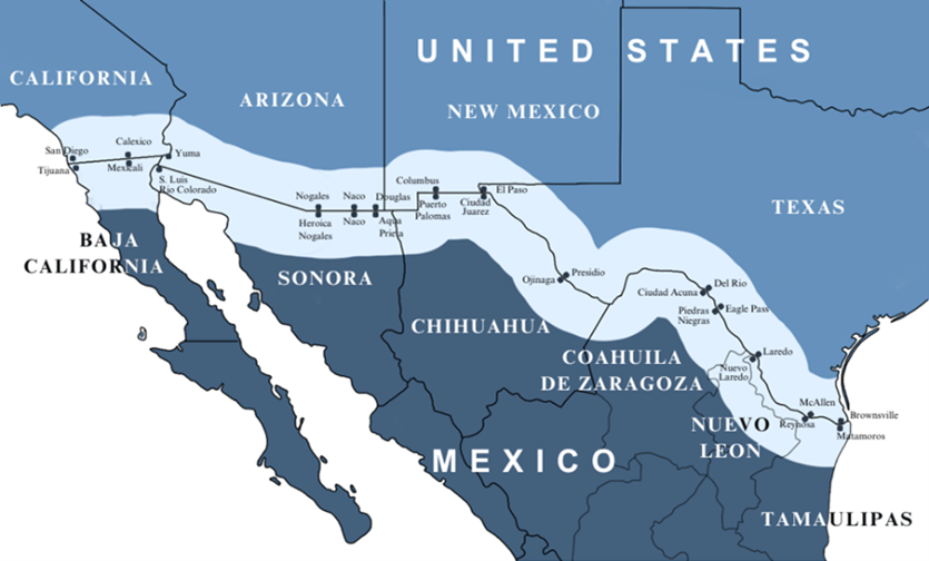
Map of the border area as defined in the La Paz agreement of 1983.
In 2020, the population of the U.S. border region was approximately 8 million people,1 while the border region of Mexico had about 8.8 million people.2
Each of the U.S. border states has different demographic characteristics but face some of the same healthcare challenges whether the residents live in densely populated urban zones, small towns, or sparsely populated rural and frontier areas. The U.S. side of the border has significant health issues related to higher rates of uninsured individuals, migration, poverty, risks for infectious and chronic diseases, and geographic vulnerabilities. The border region overall is also challenged by a shortage of healthcare professionals and medical facilities.
Commission Functions
The Commission’s role includes the following functions as outlined in the Agreement Between the UNITED STATES OF AMERICA and MEXICO:
- Conduct public health needs assessments in the United States-Mexico Border Area, and conduct or support investigations, research or studies designed to identify and monitor Health Problems;
- Provide financial, technical or administrative support to assist the efforts of public and private nonprofit entities to prevent and resolve Health Problems;
- Conduct or support health promotion and disease prevention activities in the United States-Mexico Border Area; and
- Conduct or support the establishment of an extensive and coordinated system, which uses advanced technologies to the extent possible, for gathering health-related data and monitoring Health Problems in the United States-Mexico Border Area.
The U.S.-Mexico Border Health Commission consists of:
U.S. Section
- The U.S. Secretary of Health and Human Services, or his/her delegate as Commissioner,
- Two individuals, also known as Special Government Employees (SGEs), from each of the border states, who are nominated by their respective governors and appointed by the President of the U.S., and
- The State Health Officer from Arizona, California, New Mexico, and Texas, or their respective delegates.
Mexico Section
- The Mexico Secretary of Health or his/her delegate, as Commissioner,
- One individual from each of the six border states, whom the Secretary of Health designates for the Government of the United Mexican States, and
- The State Secretaries of Health of Baja California Norte, Sonora, Chihuahua, Coahuila, Tamaulipas, and Nuevo León, or their respective delegates.
To learn more about the Mexico Section, please visit their website, Salud Fronteriza (saludfronterizamx.org)